skip to main |
skip to sidebar


I hadn't been this far out the Strait for years, and then two trips in about a month. This particular morning I caught the 5:30 Edmonds ferry and made it to Bullman's by 9AM.
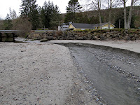
The shoreline out here is rocky, with beaches located only where some combination of shoreline configuration and local sediment sources conspire. Bullman's is a half a mile of pocket beach fed largely, as far as I can tell, by the stream that emerges in the middle. A rocky promontory at the eastern end keeps the waves coming in the Strait from spilling sand out that end. As with any pocket beach, it's orientation probably tells us as much about the angle of wave action on this beach as any sophisticated model would.
Kelp was washed up in berms at the west end, pushed against sandstone boulders that looked almost like highway department riprap (but for the most part, were not).
The backshore grades landward to meet the filled areas around the homes. This end of the Olympic Peninsula is being pushed up faster than sea level is rising (at least during the past century, but maybe not the next), so I'm guessing the shoreline is gradually marching seaward. But I wonder what the story with those huge stumps in the back beach near the west end - did they wash in (how?), or are they in growth position -- which might really complicate the story.


 By all rights, there should be no beach here at all. This was once mud flats on the delta of the Puyallup River, but progress filled the marshes and the flats, bringing dry land as close to deep water as earth-moving economics would allow. This shoreline was marked by wharves and industry - and much of it still is. But the shoreline faces into the major fetch, raising the possibility of stable beaches, and as old piles and rubble have been removed, and as sand and gravel has been brought in to cap contaminated sediment, beaches are appearing.
This site is complicated - most sites are. A small pocket lagoon has been created in order to restore marsh and intertidal habitat, something rare in Commencement Bay. But the tide must come and go through an opening that the newly formed beach wants to bridge with a berm. Storms drive the gravel up the profile, building the small spit higher and pushing it into the mouth of the inlet, where it might potentially raise the sill elevation of the lagoon. One could engineer a "stable" configuration, but maybe it's better to let the tides and the waves sort this out themselves.


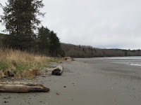
Once, the forested bluff rose directly from a narrow beach. High tides probably reached in among fallen trees and drift wood making walking on the beach difficult and canoes were probably the preferred mode of travel along the western edge of Port Townsend Bay.
In the 1880s a steel mill was built here, processing thousands of tons of iron a year. Wharves, foundries and fabrication buildings, charcoal kilns, and slag from the blast furnace spread across the site. The community of Irondale grew around the mill. But by 1900, the town's steel working origins were already history.
In the early 1900s, the whole shoreline from here north to the mouth of Chimacum Creek was buried under sand and clam shell dredged from the bay. The broad, flat, artificial landscape was a log storage yard well into the 1990s, when public groups stepped in to reclaim the site.
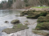
The legacy of the old mill remains. The forest grows from the moss-covered foundations of the buildings on the hill. Large concrete relics are scattered on the beach and the slag forms a small headland, resisting the southward transport of sand from the eroding shoreline to the north. Farther south, circular brick beehive kilns are eroding from the bank. The beach is littered with brick, slag, and all the other hard parts that were left behind as the sea transgressed back across the site.
It is now all part of Jefferson County's Irondale Beach Park. The northern segment was largely restored several years ago (I've written several times about Chimacum Beach) and now efforts are underway to clean up the less appealing leftovers of the old steel mill and restore the beach. The slag will probably go, along with lots of contaminated soil, and the shoreline will have to be reconfigured, but it will come back as a beach - probably not the narrow one at the toe of the bluff that existed 150 years ago, but a sandy one that encourages exploration. Historical aspects of the site will still be the central theme, a neat reminder that every beach has a story. Sometimes many.


